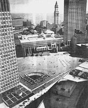
The goal of this Masters Research project is to create a juncture between four major areas within the city of Boston. These districts are the Government Center, Quincy Market, North End, and the Waterfront. The site for this project is a section of the tract of land which will be created when the existing elevated highway is demolished. According to the guidelines for development published by the Boston Redevelopment Authority a portion of this land is intended for development and the rest will be park. I intend to create a strategy to integrate the stretch of land into a cohesive whole which has a spacial and experiential relationship to its surrounding neighborhoods. Three main goals will create this relationship and drive the project: multilayered programed public space, creation of a pedestrian hierarchy, the retention and manipulation of the Edge which constitutes a division between the North End and Downtown. This edge currently is the boundary of the city core.
In Bostons proposed plan there is no substantial consideration as to how this new space will be used at multiple times of day and through the changing seasons. I feel that if there is no provision for multiple usage, this park area could become an urban void at certain times, similar to parts of Commonwealth Avenue and the Back Bay Fens surrounding of the Museum of Fine Arts. The new area must be able to sustain activity at all times, and not become a questionable non place with no real connection to its surrounding areas. It should posses areas within it allowing inhabitants various levels of exposure. Exposure in relation to the elements, as well as various degrees of public space, ranging from more public people watching spaces, to those which can be more secluded and introspective. A major element of my intentions relates to the idea of exposure.
Although Boston boasts some of the most renowned public spaces in the country, it lacks an interior public space within the downtown area. An interior public space would compliment the existing downtown and make Boston a more unified place no matter the time or season. The park must be a place which draws city inhabitants to it. It should be a spine of orientation within the city that people have confidence in the possibility of excitement no matter the time or season. It will be a place of destination and transition bringing people together from all surrounding areas. In this media age, the impression we are given is that the world is becoming smaller and that people are becoming more connected. This is true in some ways, but is it at the expense of public interaction. With so many modes of communication possible and the dispersion of our population, our society is becoming more separated in many ways. For this reason our cities take on a larger importance as epicenters for our society. Therefore the public spaces within these cities serve a major role for the surrounding population of the metropolitan areas as well as their immediate inhabitants.
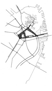
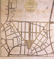
The construction of the elevated highway in the 1950s disrupted a street hierarchy which had evolved for over 300 years. The purpose of a highway is to consolidate movement and dispense travelers to specific points within the city for the sake of speed and convenience. Before the highway, traffic into the city was more evenly dispersed. Multiple routes to destinations where possible. Street organizational plans such as the Bulfinch triangle, located on the north side of the peninsula, where specifically designed for this purpose. The Bulfinch triangle successfully dealt with inbound at outbound traffic for over one hundred years. The triangle provided a sensible hierarchy. The axises where large thoroughfares to a focal point, the streets in between where more local. I do not claim that there was no need for the new highway, because there are limitations to systems like this. The highway was a neccesity, but it introduced a phenomenally large scale to a system which couldnt deal with it, and has been trying to do so for the past fifty years. The problem in Boston is that there is no intermediary scale for traffic movement. Bostons tight knit street network couldnt handle this new volume of automobiles. In response, the city cleared out whole parcels of land for redevelopment and a proliferation of parking garages emerged, specifically in the area of parcel 12. The new scale permeated through the city, but never truly was successful in dealing with the problem. The whole West End was leveled for the new Government Center and various parking structures, Congress Street became a major through street. The highway dispenses autos to specific points within the city and thus bypassed such networks as the Bulfinch triangle. The highway exit points couldnt deal with it. A successful city street layout would at those points have a continuing network of varying sized streets to diffuse traffic into the city. Boston doesnt have this, and it is virtually impossible due to the limited space. Bostons solution was the construction of the abundance of parking garages, and the creation of a new network of pedestrian possibilities. The pedestrian aspect of the city was exaggerated with large areas unavailable to autos. The Government Center and Quincy Market are examples of this. Thus the new scale of the highway was extended to the world of the pedestrian, and the whole nature of walking within downtown was altered. No longer was downtown just meandering streets, it now has parts of vast openness . Now within downtown Boston the pedestrian network is completely separate from the automobile network, similar to the way in Venice the canal and pedestrian networks interrelate. In Boston the network is not complete, and there still there are portions of the city which retaining the aspect of autos and pedestrians occupying the same streets. The North End is an example, and it should be retained. The demolition of the elevated highway provides opportunities to solve these problems and make Boston a better city. The C.A.P. is not just about getting rid of an ugly highway, but could be the solution to problems the city has been struggling with for the past fifty years. Through the submersion of the highway, Boston is automatically given a street hierarchy. The reconstruction of the Bulfinch triangle and reconstitution of the surface Boulevard will provide the new intermediary scale which never existed. Other factors such as the limiting of exits from the new tunnel and the submerging of the entrance and exit of the Sumner and Calahan tunnel will help also. The pedestrian network and hierarchy can also be enhanced if development of the new corridor of space is designed with these intentions. A new pedestrian thoroughfare can connect areas such as the Government Center, Quincy Market, Harborfront Park, the coastline walk, and the historic North End. If this where successfully done Boston would posses one the best urban pedestrian environments in the world.
The North End of Boston is an important part of this project. I feel that it is a necessary link to the history of Boston. Site of the original settlement and containing many layers of the development of Boston, it posses a great value.. The construction of the original central artery provided an urban edge which protected the North End from the extreme alteration that took place within the downtown area. Therefore a goal of my proposal is to maintain this edge architecturally. Through the retention of the edge created by the highway the North End will be allowed to evolved at its own pace, as it has been allowed to do for the past 50 years. This edge must have certain characteristics though, it must be a separator but at the same time be a unifier. This relates to the overall goal of the project which is to create an intervention uniting these separate districts while allowing them to retain their unique qualities as places and prevent an urban homogenization.